Sierra Delta:
Gabe Nutter


Lazy Hummus
Plot: This was a test to check out lighting and camera setup. This is still on track to become a regular series talking about how to cook great dishes without doing too much work.
Role: “Wrote”, shot, and edited. This was using the Black Magic Pocket Cinema 4K which I absolutely love. I just need a crew to help out. Doing all of this on your own is a lot of work. Or, better, it was a lot work because I didn’t have a process and workflow which are key in any project.

Blue Buffalo National Meeting
So Blue had a National Meeting in some place in Florida. The creative department wanted something that could play on monitors scattered around the event grounds and this was my solution. We started off with some photos that they had from last years meeting as ‘placeholders’ and over the three-day weekend I would have them upload the day & nights photos the night before and then I would update the cubes. Everyone was super impressed by the turnaround time and enjoyed seeing themselves having a blast.
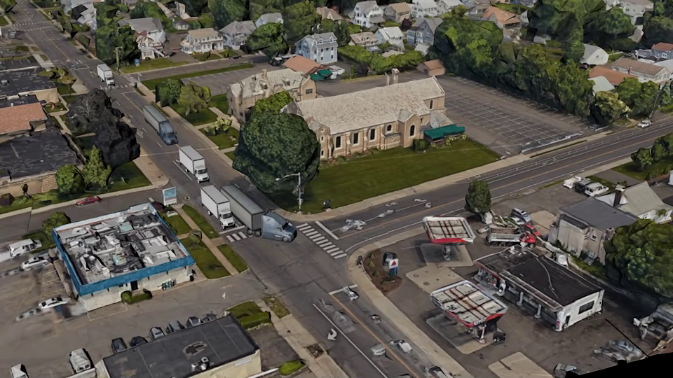
East Norwalk Fly-Around
Plot: Keep the city of Norwalk from a warehouse/distribution center from being constructed and extensively renovated 330,000sqr ft of it to become a 19-loading dock facility apparently being an Amazon distribution center whose focus be on warehouse-to-business and not a warehouse-to-consumer traffic meaning that there were going to be an estimated 198 tractor-trailers per day in this lovely little neighborhood and the community was having none of it.
Role: Create a birds-eye view of the neighborhood with additional truck traffic to make a visual point to the city council the impact it would have on the walkability, current traffic, and overall quality of life in the East Norwalk Neighborhood.
I would have done the fly-over if I had a drone so I turned to the next best thing!: Google Earth! Using Google Earth and Google Maps I was able to extract the point data as well as the textures that they were using to create the visual aspects of the maps. And it was a lot of data. So in order to create the fly-around I first grabbed the interior portions of the map which I could pull in lower-res data points and graphics. I then went back to image in hi-res all the places that the camera would see the most. Did I say it was a lot of data?... It was a lot of data.
Wallach Fetal2EMR
Plot: Explainer video to display and advertise the virtues of the Wallach Fetal2EMR.
Role: I did the 3D and animation. It was pretty straight forward.

Unigy Logo Reveal
Just some random logo reveal that I liked